![]()
|
August 2007: A trip to Spray Park |
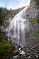
A couple miles up the trail, a small side-trip takes one to this view of Spray Falls. The size of the waterfall is difficult to discern in this photo - it's fairly immense. To get the best view (or at least the best view I could find), you have to cross over the stream on a bunch of rocks. |
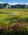
After Spray Falls, the trail quickly climbs above the treeline to Spray Park. A myriad of alpine flowers were in bloom. The mountain ridge in the distance is part of the Mother Mountains, in the opposite direction of Mt. Rainier. |
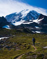
A number of unmarked side trails head off the main route toward Mt. Rainier, and other destinations. I left the trailhead before dawn, and basically had the entire area to myself for a couple hours. Then, a steady flood of hikers started arriving... Unfortunately for them clouds also rolled-in, obscuring the views of Mt. Rainier. |
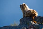
There are a lot of marmots living around Spray Park. They tend to be rather tame - used to the gawking crowds of tourists, and more interested in fattening-up on sprouts and flowers. |
A stiff cool breeze kept the mosquitoes away, and served as a reminder that the alpine summer spendor is brief and rare. |
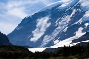
I heard a distant rumble, and turned my head to see a gigantic chunk of ice cascading thousands of feet down the side of the mountain. The ice had broken-off the edge of a glacier near the summit dome. Obviously, the area below these ice cliffs is one of the more hazardous places to be on Mt. Rainier. I had to wonder about the wisdom of people who climbed routes through this zone - no amount of equipment or experience could save you from this kind of event. It's probably smartest not to take that kind of risk. |
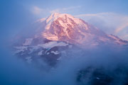
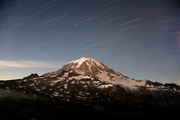
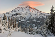
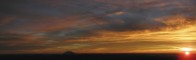
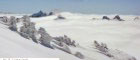
As the sun set, clouds swirled in an infinite sequence of patterns and forms. I managed only fleeting glimpses of the northwest face of Mt. Rainier, bathed in the warm glow of the day's final rays. |
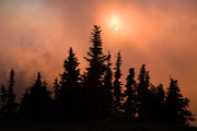
A group of Sub-Alpine Firs stand in silhouette against pink clouds of the setting sun. |

The top of a mountain is a magical place, where one can experience environments that exist nowhere else. Being in a place like this can make one feel both insignificant and enlightened at the same time. Here, the setting sun casts a human shadow on nearby clouds. |
Spending a night on top of a mountain with views to the horizon heightens one's awareness of the movement of the earth, sun and moon. I could feel the earth spinning on its tilted axis... the sun whipping behind and underneath... the half moon rising and illuminating Mt. Rainier. |
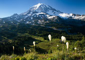
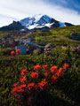
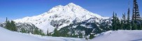
The 96-mile Wonderland Trail encircles Mt. Rainier. It cuts through the alpine meadows of Spray Park seen here. A couple flowers of Beargrass dot the foreground. |
Mt. Rainier was named for some obscure British military officer. The natives named this mountain Tahoma (or variations like Tacoma, etc.), a more fitting name meaning simply snow peak. |
|
June 2005: A climb of Mt. Rainier |
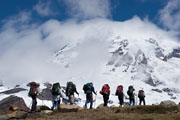
There were 4 in our party for this climb of Mt. Rainier; Matt, Ed, Graham, and me. After checking-in with the climbing station at Paradise, we left the trailhead under partly cloudy skies. Here a larger group of climbers ascends the trail, as Mt. Rainier tears up the sky in the background. |
Much of the hike to to Camp Muir is along a gently sloping snow field. We were lucky to have solid footprints to step into, it made the heavy loads on our backs easier to carry. |
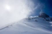
Clouds swirled around the upper slopes of Mt. Rainier - sometimes obscuring the sun, while we set up our camp. |
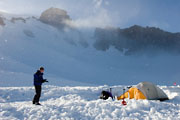
Later in the afternoon, some snow flakes blew in from nearby clouds. We got to sleep as early as possible, hoping the weather would clear. |
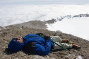
The next morning, we awoke at 1am. Everything below 9000ft in elevation was covered in clouds, but the top of the mountain was clear. We decided we had a window in the weather, and we should take advantage of it. Progress upwards was slow, but we finally reached the top around 9:30AM. A combination of thin air, lack of sleep, and general fatigue from the effort can leave a person with nothing left to give. |
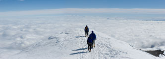
We didn't linger too long on top though. In this extreme environment, the weather can quickly turn to white-out conditions, and we were in a hurry to begin our descent. We finally made it back down to Camp Muir around 2PM, and caught-up with some sleep. |
The next morning, we headed back down the Muir snowfield and into the clouds. A series of wands roughly marked the path. The blasting of snow gives some indication of the conditions overnight. |
Closer to Paradise, everything was covered with about an inch of fresh snow. These rocks were bare when we hiked up two days earlier. It's a good thing that the top of Mt. Rainier is so high - we were able to stay above the clouds and nasty weather. |
|
November 2004: Overnight on Mt. Ararat |
I left the Kautz Creek trailhead around 11am, destined for the slopes of Mt. Ararat, a 6,010ft minor summit just to the south of Mt. Rainier. A mile from the trailhead, I was pleased to find a new bridge over Kautz Creek. The "bridge" was only a roughly hewn log with a railing, but that's all one really needs. I reached the snow line at about 3,500ft. The snow on the ground slowly got thicker as I continued to climb up the trail. At one point, I took a break under a huge fir tree as the cloudy sky produced a few new flakes. It got a little more difficult to locate the trail as it broke out of the trees and crossed open snowy meadows, but I managed to stay on track At around 5,000ft elevation, the snow was thick enough for me to switch to snowshoes. I continued up to a snowy bench at 5,900ft, just below the top of Mt. Ararat. It was nearly 5pm, and just starting to get dark. I set up my tent, and settled in for a long cold night. |
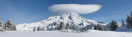
The skies cleared overnight, and I awoke to a magical scene. A lenticular cloud had formed over the top of Mt. Rainier, and the rising sun made it glow a pastel pink. |
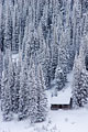
Mt. Ararat is located just south of an area known as "Indian Henry's Hunting Ground". Local Indians used to hunt in the area, but that's been banned since 1916 in Mt. Rainier National Park. Now, a backcountry summer ranger station is nestled among the trees and meadows there. Later in the winter, the small building will likely become completely buried by the snow. |
The temperature dipped down to 21F overnight - at least inside my tent, probably a couple degrees cooler outside it. After the sun rose and warmed things up a bit, I headed up to the top of the mountain. |
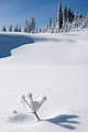
The autumn snows flooded the landscape with white. Here, the tip of some long expired plant pokes through, as if gasping for one last breath of air before winter seals its fate. |
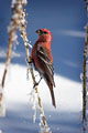
As I headed back down the mountain, I passed through a small flock of Pine Grosbeaks. These colorful birds were feeding on plentiful Beargrass seeds. |
I saw only one other person during this trip. I don't know whether to be thankful or disappointed to have such places and times to myself. It is nice to have the peace and solitude, but I wish that more would understand the value of these things. It does take some effort to complete such a trip, but when the trip is so enlivening, it is simply worth that effort. And in part, it is the effort itself that makes the trip so rewarding and valuable. |
|
August 2004: A dayhike to Panorama Point |

Clouds around Mt. Rainier were just lifting as we started this hike to Panorama Point. This entertaining marmot along the trail ignored the crowds of gawking tourists, and continued with his business of fattening-up for the coming winter. |

Panorama Point is a point on a ridge with a nice view in all directions. This photo shows the view of some surrounding ridges leading from the top of the mountain. |

The trails to Panorama Point can get pretty crowded during the summer months, but the crowds do thin-out a bit as one ascends to higher elevations. |

The mountain drifted in and out of view while we continued our hike, giving it a somewhat mysterious quality. |
|
February 2004: A loop trip along the Muir Snowfield |

Mt. Rainier can be a beautiful place in winter. But, the weather is often too harsh to allow for a pleasant outing. |

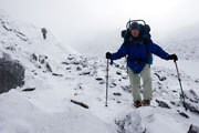
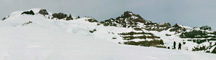
Although the skies were relatively clear this day, the strong winds blasted everything with grains of snow lifted from the surface. Here, a few determined backcountry skiers attempt to adjust their gear. |

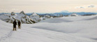
We originally planned to head up the Muir snowfield, but the winds made progress tough. Instead, we traversed to the northeast below Paradise Glacier. The valley offered some protection from the wind. |

Soon, the winds shifted, and it became quite calm. We watched as some telemark skiers made tracks up the valley below us. |
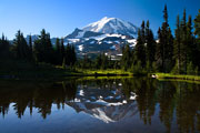
At about 7,400ft, we finally reached this view of the Cowlitz Glacier and Little Tahoma peak (just right of center). The summit of Mt. Rainier is to the left of this photo. |
We completed our loop down this magical valley of softly sculptured snow. Mt. St. Helens rose from the horizon far to the south. |
|
August 2003: A trip to the Round Pass area |
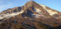
The west side of Mt. Rainier was once a very popular hiking destination. Since the road washed-out a number of years ago, it takes a bit more work to reach the many trails. I drove my car to the wash-out, then biked 4 miles to Round Pass. From Round Pass, it's a 2.4 mile hike to the lookout on Gobbler's Knob. This is a view of Mt. Rainier from the Gobbler's Knob lookout. |

This is a view of the Gobbler's knob lookout from the trail below. |

After the Gobbler's Knob hike, I headed toward the mountain along the Puyallup River then up the Wonderland trail to St. Andrews Park. This is a view of St. Andrews Lake from the trail. |
|
February 2003: A night at Camp Muir |

Camp Muir, at 10,000ft on the SE slope of Mt. Rainier, is always a great overnight destination... as long as the weather is decent. |
The weather was excellent on this outing. It got quite windy overnight, but the temperature barely dipped below freezing. This photo shows the view south toward Mt. St. Helens at sunset. |

The snow levels on Mt. Rainier were very low. Apparently, there is only 60% of the average snowpack for this time of year. After seeing it for myself, I'd say that's a high estimate. Of course, even a low snowpack on Mt. Rainier is a lot of snow... but the glaciers need even more to stay healthy. |

This is a photo of Mt. St. Helens from the Muir snowfied on Sunday morning. |

The nice weather brought a good number of people to the mountain. About a dozen spent Saturday night at Camp Muir. Most of those intended to climb the mountain the next morning. In the morning, we did see some footprints headed up the climbing route, but many other climbers remained in their tents... possibly because of the windy conditions. |
|
October 2002: Overnight trip to Pyramid Peak |
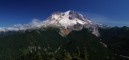
Pyramid peak is immediatly south of Mt. Rainier... which dominates the view. Pyramid peak is the near peak on the right side of this photo, Mt. Rainier is at center. The route to the top of Pyramid peak follows the right ridgeline. |
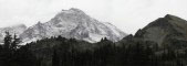
This is about as snow/ice-free as you'll ever see Mt. Rainier. In fact, it almost isn't recognizable. There was a lot of melt during the warm, sunny summer & the season's first real snow had yet to fall. |

It was getting cold though, as can be seen by this small pond near the base of Pyramid Peak. |

We camped in the area just below the peak... near where this photo was taken. It's about 7 miles from the nearest trailhead. On top of Pyramid peak, we met a young Russian man, in his mid-twenties. I asked him why of all the places to go in the world he was here. "Because it's the best", he replied. |

We had beautiful & mostly clear weather for the first day, with views for dozens of miles. This photo shows Mt. Adams in the distance from the top of Pyramid Peak. A small storm came in overnight and deposited a couple inches of snow on the higher elevations of Mt. Rainier. |
|
June 2002: A climb of Mt. Rainier |

I just got back from a climb of Mt. Rainier. Our group consisted of 5 people... Seen in this photo from right to left are Joan, Jeff, Dirk and Loren. |

We climbed the most popular route: Camp Muir - Disappointment Cleaver. We took our time getting to the top, which made for a pleasant experience. We spent the first night at Camp Muir (~10,000ft), seen in this photo. |

On day 2, we camped on a snowy bench at the top of Disappointment Cleaver, just over 12,000 feet. This photo was taken soon after sunrise on Day 3. Some other climbers (little black dots) can be seen further up the mountain. |

This is a photo of some large crevasses on the Ingraham Glacier, at just over 11,000 feet elevation. |

The summit of Rainier is 14,410 feet. There is a volcanic crater on top & even some thermal vents. We had excellent weather on this trip. Although, a couple minutes after we reached the summit, the wind picked up and a thick cloud reduced visibility down to about 30 feet. As we descended, we dropped out of the clouds. |

Getting up the mountain is only half the trip though... It's been said that you never really climb a mountain until you're back at the trailhead. The white river in the distance is about 6000 vertical feet below Joan in this photo. |
|
March 2002: A day-trip to Camp Muir |

The elements of sun, clouds, snow & trees all came together for this scene. |
It snowed about 6 inches the night before we did the trip. Snow on Mt. Rainier rarely falls "straight down". |

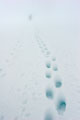
Some people were trying to ski down the snowfield, but were having a tough time due to the icy snow drifts. The drifts on this photo were about 1-2 feet high. At one point during our descent, we were completely shrouded in a thick cloud with no point of reference - everything was just white - it was hard to determine exactly where the surface of the snow was. It was a bizarre feeling. It would have been easy to get lost if it wasn't for faint footprints in the snow. |
|
January 2001: A snowshoe trip to Mt. Ararat |
Mt. Ararat is immediately south of Mt. Rainier. A trail leads from the Kautz Creek trailhead toward Indian Henry's hunting ground (about 5 miles). It's an easy side-trip to go up Mt. Ararat. |

Snowshoeing is a blast. It's like walking on water (literally!). If you can walk, you can snowshoe! |
Where is it? Mount Rainier is about 80 miles SE of Seattle, in the southern Washington Cascades. The mountain is enclosed in Mount Rainer National Park. |
Before you go... There's a $20 entry fee (per vehicle) to the park. You can get an annual pass for $30 or a national parks pass for $50. |