![]()
Route
I've created this page to help answer some more detailed questions I often get about the route we took through Iceland, and just "getting around" more generally. I don't claim to be the world's expert on Iceland, and the information I do have is all based on one trip in 2006, so some of it might be less valuable with the passage of time. There are a lot of possible routes across Iceland in a number of directions... This isn't intended to be any kind of
"official route" or anything - only a description of what we did... This is also all written with my personal perspective as an American with some long-distance hiking
experience, so please read with that in mind too - my perspective might differ from yours.
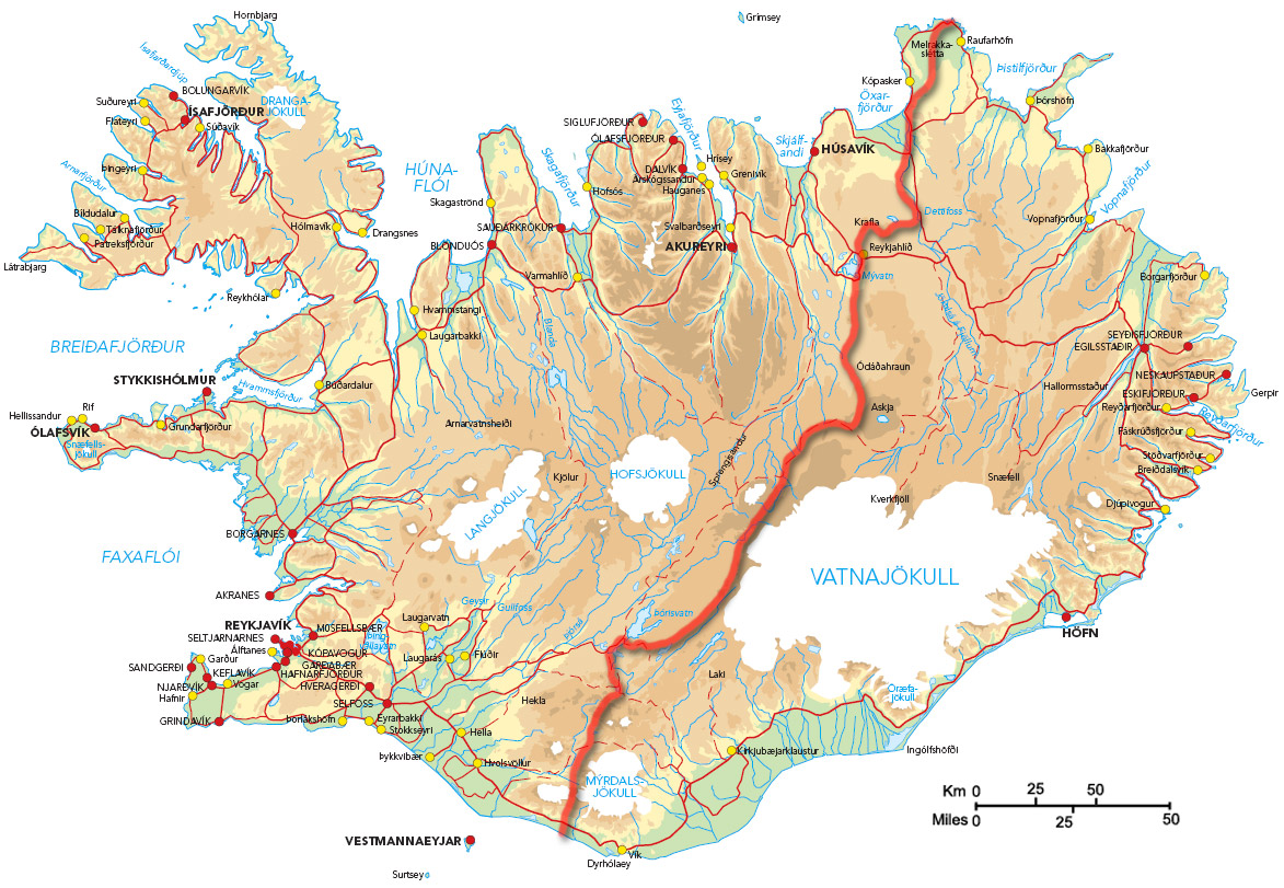
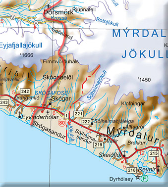
Overview Map
This map shows the route, as well as some major towns of interest. Note Keflavík & Reykjavík on the SW side, Akureyri, Húsavík and Raufarhöfn on the north.
click to enlarge
Getting There
You'll arrive at Keflavík airport, which is about a 30 minute drive from Reykjavík. You can rent a car at the airport (and return it in Reykjavík), but taking the bus is an easier and cheaper option. You don't need to go to Reykjavík actually - other than to catch the bus that'll take you to the start of the hike - but most people will want to spend at least a little time there... I mean, how often will you get the chance to check-out Reykjavík? You could stay in Keflavík, or some other smaller town more cheaply,
but let's just assume you're going to Reykjavík...
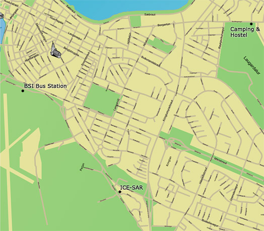
You'll likely be arriving with your pack, and some amount of "stuff" you're not planning to carry across the country - like street clothes, etc. Even if you're not planning to stay in a hotel in Reykjavík (which can be expensive), it might be a good idea to book a night for "after the hike", so you can clean-up & re-group. They will probably be willing to hold a small bag of your stuff in the office if you're planning to return there. The only issue is that you might not exactly know when you'll be getting done. There's not much you can do about that except guess! I don't know if there are any "public lockers" somewhere in town, but it sure would be helpful! There is a campground in Reykjavík & a hostel too, but they're a little more distant from the "heart" of downtown and the bus hub (which you'll need to get to). There is a pretty good system of city buses however. A very simplified map is shown here to give you some idea of where stuff is.
Remember that Iceland is a big tourist destination, and things (like the hostel, hotels...) book-up early in the summer. Do a little research, and call /e-mail ahead...
To the Northern Tip
Getting to Hraunhafnartangi takes 1.5 days due to the bus routes. The first day you can either go to Akureyri, or Húsavík. The next morning, you'll catch another bus route toward Raufarhöfn. Akureyri is a bigger town with more grocery shopping options (though, the Bonús foods - cheapest - is a bit of a walk out of town on the north side). Húsavík is cuter, and certainly fully-functional (i.e. you can buy food). They both
have good, grassy campgrounds.
There is no scheduled stop at Hraunhafnartangi, but you'll be in a small van and can just tell the driver where you want to stop.
Another option for part of this leg is to fly from either Keflavík or Reykjavík to Akureyri. Apparently, the cost is very similar to the bus, and the view is better.
Hraunhafnartangi to Ásbyrgi
You'll get off the bus, and have to walk north a couple km to get to the lighthouse and the northern shore - it's definatly worth doing. Technically, Rifstangi might actually be further north (so, if that kind of thing is important to you, go there too - but I hear it is more swampy). Then head south along the road for while before turning off on an unmarked "track". You'll probably second-guess exactly where you need to turn south into the tundra. The "way" is very indistinct at times,
but just keep going. A gps (along with some coordinates) can help here.
This goes south through tussocks and tundra for some time. We never did find the lake Beltisvatn (neither have others... I don't know where it is in relation to the track but the map shows the track going right by it!), and there isn't any water south of the paved road, so keep that in mind. We eventually came to a string of power lines, and followed the power line access road to the west, toward Kópasker. We then headed south (where water is available) through rolling farm/ranch lands along a mix of access roads, paths, and cross-country. Some of this might have been private property, but we saw no people or signs. We came to the cliffs near Núpar, and decided to go along the base of the cliffs because we didn't have a good map of the interior in this area. Eventually, we got squeezed onto the paved road and walked that to Ásbyrgi.
I've drawn a purple line - alternate - that shows a possible route inland. This would probably take an extra day, but would be nice to try if you had a decent map. It would be over rolling terrain - there are a lot of cliffs in the area, so you'd have to know where you're going. Eventually, you'll have to get to the road and cross the bridge that's the only way across the giant river Jökulsá á Fjöllum.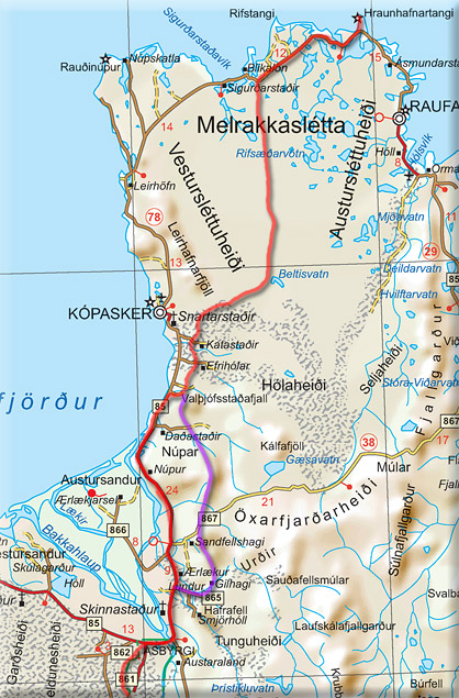
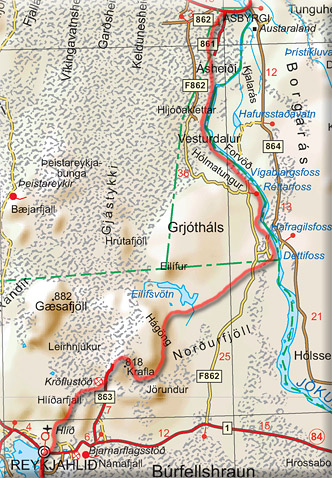
Ásbyrgi to Reykjahliđ
Ásbyrgi is the name of the canyon at the northern end of Jökulsárgljúfur National Park. It's just a lot easier to say "Ásbyrgi" than to say "Jökulsárgljúfur". Near the park entrance, there is a gas-station & mini mart that has decent supplies. It doubles as the campground store, so you can stock-up pretty well there. Prices might be a little steep though. There are coin-operated showers in the busy campground as well, and pay phones. The trail through Jökulsárgljúfur National Park is pretty
well-marked and good tread. It follows the grand canyon of Jökulsá á Fjöllum all the way to Dettifoss.
There is one section just north of Dettifoss where you're presented with an option to head down near the canyon or detour around a side canyon. We chose the detour route as the canyon route is dangerously eroded in parts. We talked to others who took the canyon route and described it as "sketchy" and dangerous. I think we were happy with our choice.
After being gobsmacked by the incredible sight of Dettifoss, you head cross country into the bleak expanse toward either Elifur of Elifsvötn. The route we hiked took us around the southern end of Elifsvötn (where there is a very rustic, mouse-infested, shelter... which is good to get away from the midges, but not much else), and into the hills of Hagong. All of this is cross country, and it helps to have a gps. We weaved around the south part of the hills, and then north around the top of Krafla.
Krafla itself (the actual volcano) is rather unassuming, and has some kind of radio tower on top. Head around the north side of it to pick-up the various trails that take you through the geological wonders... If you head south of Krafla, you'll end up at the geothermal power plant.
Head down the paved road a couple miles, and you'll pick up a trail that takes you all the way to Reykjahliđ. Before heading south, you might consider a quick loop trip through the still-steaming recent lava flows just north of that same trailhead... This is where all the tour groups are going - and it's cool to see. Large sections of the trail south are simply trail markers through some pretty rough lava - don't slip!
Reykjahliđ into the Highlands
Reykjahliđ is a full-service town. There is a post office where you can mail a package, and a pretty good grocery store at the gas station. Reykjahliđ is the main town along the shore of Mývatn, so there are all the regular services you might expect. There's a pretty good campground across from the gas station, along the lake shore (grass, showers, phones, internet...). You'll probably take the road around Mývatn. There is a trail through part of the hills on the NE of the lake however, so you could piece-together
a route through there... possibly. But, you'll likely have a long haul ahead of you, so you might just want to get moving.
The turn south is pretty obvious. The road will get less and less distinct as you approach Sellandafjall, which you'll be able to see for a long time - good landmark. There is a hut immediately south of Sellandafjall, but it's a couple miles off the route. There are a number of small streams to cross in this area - not difficult, and good for water. There are sheep in the area though, so it's a good idea to treat your water. There is a hut at Botni that's open to use (provided somebody hasn't booked all the bunks in advance) - be sure to leave them money for the stay if you use the hut. This hut will be shown on most more-detailed maps. There are a few choices as to where exactly you go through here - a couple different roads that ultimately lead to the same place. It's generally easiest to follow the roads as there aren't a lot of landmarks, and there are various lava fields that can make cross-country progress difficult.
I've drawn another "alternate" route heading further east. This route will take you past Askja. I know people have hiked this way, but I don't know exactly what the terrain is like - i.e. how gnarly the lava is. There is an established, marked hiking route that you can link-up with nearer to Askja, and it'll take you back to the "red" route (as I've drawn in the next section).
South of Botni, the landscape gets a lot more desolate. Black rock takes over, the sheep are gone, and there are some really gnarly lava fields "off the track". The track is only marked in a couple places. Mostly you just have to pay attention to where you're going - look for cairns, worn rocks, and such...

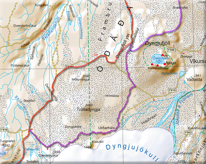
Askja and Trölladyngja
There is another hut in the valley of Dyngjufjalladalur (say that 5 times fast!). It's possible to do a little loop that'll take you up to see Askja. Another option might be to base yourself at the hut, and do a day hike to Askja/Öskjuvatn/Víti and back to the hut.
South of the hut, the canyon narrows (we had some nasty sandstorms in there). Next, you have a choice to make - whether to go north or south of Trölladyngja. Heading cross country here for any serious length is not really feasible - the lava can get really bad, and there are many overlapping flows, so even if things look good to start with, you could run into a brick wall of unnavigable lava. Still, you can do some cross-country shortcuts where the road bends... for example, we cut along the south part of Dyngjulfjöll (a bunch of barren hills), which worked pretty well. The south route would appear at first glance to be more interesting. However, I've heard that you're so close to Vatnajökull you can't really see it. Plus, that route can be snowed-in until later in the season... so if you're hiking in late June, this could be a problem. We took the route around the north - cutting off bits and pieces with cross-country travel. This is an "F-road", so it's marked with stakes at regular intervals... usually.
Eventually, you'll need to get to the bridge over Skjálfandalfljót. The river here is pretty significant... and although you can ford it further south (where it's split into smaller streams), people have been killed on the fords (that's why they built the bridge). So, the bridge is a good idea.
After the bridge, you'll slowly ascend to the pass between Vatnajökull and Tungnafellsjökull.
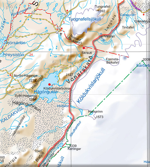
Along Vatnajökull
As soon as you crest the pass, the entire valley south opens up, and it feels like you've entered a new area. The giant deltas ahead are a maze of rock and water. Once you descend, it's hard to see exactly where you need to go. So, it's helpful to have a few key GPS waypoints here to help you through. Initially, you'll want to keep more to the west of the valley, then eventually swing back so you're very close to the ice. There is a popular hut at Nýidalur, and it might make a good pit stop. But you'll have to
do an out/back over another pass to visit
it. The F26 bus stops at Nýidalur, so that's something to keep in mind.
Heading south there is an established route, and you'll likely see 4wd tracks here and there... sometimes for miles at a time, sometimes compeltely absent. Just keep the big wall of ice on your left.
The next landmark is the crossing of the Sveđjá. This is the outflow of Hvitalón. This river can be a beast if there's a lot of melt or rain, but when we crossed it, it was thigh-deep and ~medium-swift. It is quite cloudy however, so footing is a challenge. If the crossing doesn't look good, you can head upstream a mile or so to a point where the river splits briefly, and try there.
The Hamarskriki hills just to the south of this crossing have beautiful views over Vatnajökull. Just pray for good weather, because it'd be a terror in driving rain/snow. There is nowhere to hide. The hills are also very confusing - there are a variety of criss-crossing 4wd tracks up here. It's another place where it's good to have some GPS waypoints.
Eventually, you'll get out of the hills at an emergency hut (for emergency personell, not for use in an emergency), and from there south to Jökulheimar, the route is pretty clear.
Jökulheimar to Landmannalauger
Jökulheimar is a privately run hut at the end of F229. It'll be locked unless someone is there, and I believe you need to book it in advance. It looked quite nice inside through the windows. F229 south is fairly obvious - over endless black sands and lava dunes... one of the many otherworldly landscapes along the way.
You might be tempted to try to cross the Tungnaá and walk the road up Tungnaárfjöll. Forget it. The Tungnaá is a beast, and the area you'd have to cross near Jökulheimar is a lava-wetland-delta with a lot of streams you'd have to swim.
The one choice you have is whether to head further south into Veidivotn. This is the "Lake District", and a popular get-away with Icelanders. I think it'd be pretty cool, but we were running short on time, and just headed along the main route. You could easliy walk cross country just about anywhere in this area.
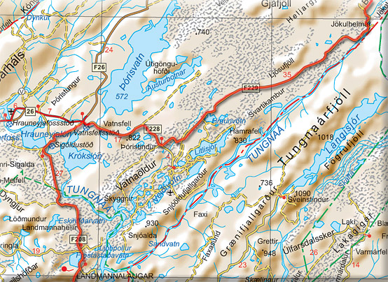
As you get toward ţórisvatn, the road will become paved, and traffic will pick up to maybe a car an hour or so. Your goal is the bridge over the Tungnaá. From there, it's more roadwalking south... there are some trails you can pick-up as you cross into the Fjallabak reserve and get closer to Landmannalauger. There are a lot of hiking maps of Fjallabak, so check those out.
Landmannalauger to Ţórsmörk
The Fjallabak trek from Landmannalauger to Ţórsmörk is the most well-know long route in Iceland - for good reason, it's simply an amazing place. It's all marked very well, and there will be a lot of hikers. Landmannalauger has a large campground, and a camp store where you can buy supplies. It's a bit pricey, but they have a lot of stuff crammed in there. Be sure to ask for cheese, which they keep in back! You can also put a box on the bus back in Reykjavík, and pick it up here. Will it be there when
you arrive?
probably... it's best to try to contact the store operators beforehand to make sure everything is ok, and what to write on the box.
There are a series of huts every 8-10 miles to the south. You have to stay either at the huts (which you can reserve ahead, or get lucky with an empty space - which is not uncommon.) Each hut has a "keeper" working there over the summer to manage reservations and such), or camp in the grassy areas that are near each hut.
There are a couple worthy side trips along the way. Be sure to check out the "ice hole" and the "canyon" both ~2 mile side trips from a couple of the huts. These are marked on the maps, and the hut keepers will know all about them.
Ţórsmörk to Skógar
The Fjallabak trek officially ends at Ţórsmörk. I don't know why, because the next short section is spectacular. Again, there are good maps and the route is well-established. Just make sure when you get to the Skóga river, follow the river, not the road. This is an amazing canyon of endless green walls and fantastic waterfalls. You'll wind up right at Skógafoss.
There is a campground at Skógafoss. From here south, just cross the ring road, and keep heading south on some farm roads. It's a long walk to the beach.
If you want to finish at the official "southernmost point" of Iceland, you'll need to head southeast, to a point just east of Vík.
Back Home
Skógar is on the ring road. The bus stops right there. You could bus it directly back to Reykjavík, and fly home. But, there are so many neat things to see along the coast, you might consider staying a while... Consider taking the bus the other direction around the ring road, or better yet - renting a car back in Reykjavík for a week and staying in campgrounds. A car rental is a bit more expensive than a full-circuit bus trip, but gives you many more options of where to go, where & when to stop & for
how long... There
are a ton really cool places that the bus doesn't go to or stop at. When we took the ring road, we were stopping every 20 minutes to gawk at the next natural wonder, or just to breathe some fresh air.