![]()
|
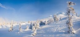
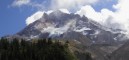
May 2007: A short hike up the Elk Cove Trail to a viewpoint |
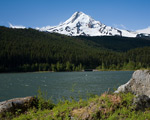
For some reason, I think of Lawrence Lake as "Lost Lake's white trash cousin"... Ok, maybe that's a bit harsh... this is a dammed lake, which takes away some of the charm that mountain lakes should have. The view is decent I guess... Actually, there is a nice view up a valley that's the source of the lake as well - just a pleasant forested valley. The Elk Cove trailhead is a little less than a mile beyond the lake. The first mile of the trail is along a closed road, but it turns to trail after that. |
There were quite a few blowdowns (blown-down trees) along the trail from the previous winter's storms. It's a reminder of just how much work it takes to keep trails from being "lost". If not maintained for a few years, a trail like this will become un-hikeable. After a few miles uphill through the woods, the trail comes to a brief open view at the top of a cliff with an unobstructed view of Mt. Hood. The wind was gusting fiercely on this day, and from the look of the tattered clouds near the summit it was blowing quite a bit harder at the top. |
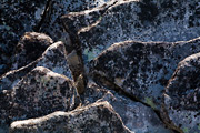
This is close-up view of some of the rocks near the open area along the Elk Cove Trail. |
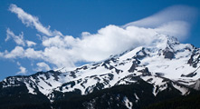
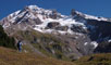
This is a close-up view of some of the clouds high on Mt. Hood. Elk Cove is a high mountain valley on Mt. Hood's northern side. Most visitors to Elk Cove go there via other, shorter trails. But I kind of liked the solitude on this day... despite a healthy holiday crowd down at the lake, nobody else went up the trail... what's wrong with people? |
Just before the viewpoint, the trail enters the Mt. Hood wilderness. It occurs to me that a lot of people who read these writings don't really know what a "wilderness" designation really means. In 1964, the US Wilderness Act was passed. This allowed the designation of certain areas of public lands to be official "wilderness areas". Wilderness areas are intended to be left to be ruled by the laws of nature. Among other things, this means that no motorized vehicles or equipment are allowed in wilderness areas. In a way, it's kind of like stepping back in time - or at least stepping out of the modern world of craziness... which is kind of the idea. |
|
April 2006: Attempted Climb of Mt. Hood |
This trip was something of an anniversary for me - 4 years to the day earlier, I first climbed Mt. Hood (see below). On this trip I was joined by fellow climbers Loren and Carl. |
Timberline Lodge was giving free lift tickets halfway up the mountain in memory of Richard Kohnstamm. He was the patriarch of the Kohnstamm family who runs Timberline Lodge, and recently passed away. We graciously accepted the offer (shortening our uphill climb somewhat), and proceeded up to a small saddle near Illumition Rock, where we set up camp. |
The icy walls of some nearby cliffs reminded us of how harsh the winters get here. |
Overnight, the winds grew progressively stronger. By the time we were ready to break camp the next morning, the gusts were so bad it was difficult to remain balanced. The tent nearly ripped apart as we took it down. Although it was a clear day, the strong cold wind was going to make it a very difficult day to make the summit. So, rather than attempting a most likely futile and possibly dangerous climb, we decided to just call it a successful "overnight camping trip", and head back down. |
|
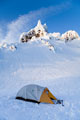
February 2006: Snowshoeing above Timberline Lodge |
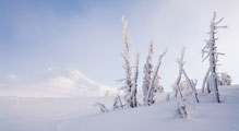
After weeks of nearly endless rain and snow, the blue skies finally returned over the northwest. I took the opportunity to make a quick trip up to Timberline lodge and explore the winter landscape. |
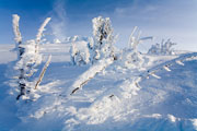
The winds were fierce the previous day, and everything above the surface was covered with a layer of icy snow. |
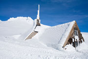
The Silcox Hut is a small building located at 8000ft elevation on the south slopes of Mt. Hood. The stone and wood structure contains bunks, a small kitchen, and a dinner hall. The indoor decor is in the same simple yet elegant style of Timberline Lodge. |

The only way to reach the Silcox Hut is to walk, ski, or take the snow cat from Timberline Lodge. |
Another view toward the summit of Mt. Hood from the area above Timberline Lodge. |
|
September 2004: Dayhike to Yocum Ridge |

The trail to Yocum Ridge, on Mt. Hood's southwest side, passes by Ramona Falls. This photo shows one small section of this beautiful cascade. Lower on this page, there is a photo of the entire waterfall. |
About 4.5 miles from Ramona Falls, the trail finally emerges from the trees. This trip is a rather long day-hike, and may be more enjoyable as an overnight backpack. |

The recent wet weather has made this an excellent season for all variety of mushrooms. |

At higher elevations, the recent moisture has fallen as snow, giving Mt. Hood a fresh white blanket. |

Here, another tiny mushroom pokes through the moss. |
|
July 2004: A hike along the Timberline Trail from Cloud Cap |

Cloud Cap / Tilly Jane is a trailhead area on the north side of Mt. Hood. The trailhead is reached by a 9-mile bumpy, dusty dirt road that tops-out at 5,800ft. The drive might not be much fun, but starting so high-up means the hiking is a bit easier. The trail quickly reaches this area below the Elliot Glacier. A flood/landslide a few years ago wiped-out the trail, which had to be re-routed further up the mountainside. |

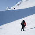
I edited this picture to emphasize the scale of the hiker in a stark landscape of rough volcanic boulders. The boulders are actually a lovely reddish color if you wanted to know. |

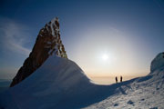
Fleeting glimpses of the upper mountain are visible from the trail, which mostly stays just below the tree line in this area. However, it's an easy hike up any number of hillsides for a more expansive view. |

Flowers were in full bloom - nearly too many varieties to count! Here a fly busily forages through one of the blossoms, pollinating it in the process. |

The distant views were mostly hazy, but the air started to clear a little later in the day. Here, Mt. Adams can be seen to the north. |
|
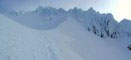
January 2004: Snowshoe Trip to Cooper Spur |

Cooper Spur is a ridge on the north side of Mt. Hood. It's also a "catch-all" name for many things on the north side of the mountain. |

There is a warming hut and shelter (Cloud Cap Inn) near the 6,000ft level. This, much simpler shelter is near the 7,000ft level. The entrance to the shelter was caked with icy snow. Scroll down on this page for a view of this same shelter on a much warmer day. |

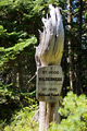
I started this trip at the Cooper Spur ski area 3,800ft, and climbed to about 7,000ft. The Timberline Trail traverses this part of the mountain at the 7,000ft level. The clouds lifted for just a few moments, allowing me to spot this Timberline Trail marker sticking out of the icy snow. |

In the summer, this area is a broad meadow of small volcanic rocks and hardy flowers. In the winter, it gets subjected to some rather extreme weather. It was cloudy & foggy for most of this trip - not the best for a variety of photos. Minutes after I snapped this photo, the clouds closed-in for the last time, and it began to snow rather heavily. |

The Cooper Spur / Cloud Cap / Tilly Jane (or whatever you want to call it) area is popular with backcountry skiers. Skiing conditions up high weren't the best, but they were quite good just a bit lower among the trees. Just before these two skiers headed down the mountain, one of them commented, "Time to start falling...", and then proceeded to wipe out. I sometimes wonder why they do it. |
|
August 2003: A day-hike to Paradise Park |

Paradise Park is an alpine meadow area on the south slopes of Mt. Hood, at about 6000ft elevation. |

The flowers were in full bloom. This is a photo of some beargrass that was just about finished blooming. |

It's about a 3-4 mile hike to Paradise Park from Timberline Lodge (along the Pacific Crest Trail / Timberline Trail). Along the way, the trail crosses zigzag canyon, which involves a drop down to the canyon and then a climb up the other side. Still, it's only a moderately strenuous hike. |

In a few weeks most of these flowers will be finished blooming, a few weeks more and the first snow may fall. |
|
October 2002: A day-hike up to McNeil Point |
This is a view of Mt. Hood from the northwest, along the Timberline trail. We started our hike at Lolo Pass to the north of Mt. Hood and continued south along the Pacific Crest Trail until we picked up the Timberline trail & headed "clockwise". |

Winter is on its way! This little stream was frozen until late in the day. |

A lonely tree near Lolo Pass makes a striking image. |

It's sometimes hard to think that this gnarled skeleton of a tree was once alive. |

The rocks above McNeil Point are a great place to contemplate many things. |
|
September 2002: Around the mountain on the Timberline Trail |

The Timberline Trail is a 36 mile route around Mt. Hood. The trail heads up and down over all the ridges and valleys that emanate from the top of the mountain. In all, the trail gains over 11,100 ft of elevation. Some people take 4 or more days to hike the Timberline trail, others run it in one day. It took me about a day and half to complete the loop. (It's not a race by the way!) A third of the trail, along the west side of the mountain, is the same as the Pacific Crest Trail. Ramona Falls, pictured here, is in that section. |

The trail reaches a maximum elevation of just over 7000ft in this area on the north side of the mountain. Cooper spur (the second most popular route up the mountain) is the snowy slope at the middle-left side of this photo. |
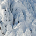
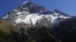
This is a photo of the Elliot Glacier on Mt. Hood's northeast side. For reference, Cooper spur is to the left side of this photo. |

This flower is called Subalpine Mariposa Lily, or "Mountain Cat's Ear". |

There are a few stone shelters along the way. I wouldn't call the accommodations "cozy" though... these are more like emergency shelters. This one is on Cooper spur. |
I hiked about 2/3 of the trail the first day & the other 1/3 the next. In the afternoon of my first day, I met a person who was running the trail in one day. He looked pretty beat, but it seemed that he'd make it. The next morning, I met two others who were attempting the same thing... Most people take a more relaxed approach though - more like 3 day hike. |
|
April 2002: A Climb of Mt. Hood |

I started this climb at 4:30AM from Timberline Lodge, and reached the top at 9:30AM. It was a weekday, so there wasn't much of a crowd. Conditions were nearly perfect, a cloud over the mountain kept the snow firm until I was almost all the way down. |
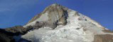
This is a photo of the "Hogsback" near the top of Mt. Hood. Two climbers can be seen just above a crevasse. This crevasse is nicknamed "The Schrund", and is usually somewhere across the hogsback (bigger later in the year). From where the climbers are standing, it's about another 100 vertical feet behind & above the ice formations to the top (which can't really be seen very well on this photo). The hogsback is about a 45 degree slope (I think). |

At this elevation (near the top) the snow is so much brighter than the sky that it's difficult to get "blue sky" to show up on a photo like this from certain angles. |

The descent involved a real treat - a great glissade of about 3000 vertical feet... nothing like sitting on your butt when the mountain has just about kicked it. |
Where is it? Mount Hood is about 50 linear miles east of Portland, OR. There are a number of trailheads around the mountain. The most popular access point, Timberline Lodge, is on the south side of the mountain, north from Hwy 26 & the small town of Government Camp. |
Before you go... You don't need any special parking permit to park at Timberline Lodge (except in winter, when you'll need a sno-park pass). At most of the other trailheads, you'll need a NW Forest Pass in the summer or a sno-park pass in the winter (at those trailheads that double as sno-parks). |
[an error occurred while processing this directive] |