![]()
|
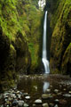
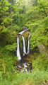
November 2008: Lower Moffett Creek Falls |
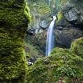
This was a short trip up a creek without a trail, to a waterfall not visited by many... in one of the most visited corners of Oregon. This waterfall along Moffett Creek is about a half-mile upstream from where the Gorge Trail crosses Moffett Creek. |
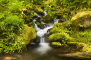
Just below the falls, Moffett Creek winds through a series of large boulders covered in mosses and ferns. When you reach these boulders you know you're close. Everything is covered by layers and shades of green... and it's greener in the winter, when the moss color isn't obscured by brown growth, and the wetness gives everything an extra lush texture. |
Moffett Creek rolls down the canyon. There is a series of waterfalls upstream from this one, stretching back for a couple miles through rough terrain. That part of the canyon is rarely visited... an ounce of wildness in an otherwise tamed world. |
These waterfalls create their own mini environments as they splash over ancient walls of lava. The constant spray and occasional flooding torrent creates an environment that is more hospitable to moss and fern than trees. The result is a small open space in an otherwise thick forest. |
|
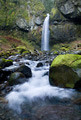
October 2006: A visit to points along Oneonta Creek. |

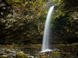
I was surprised to find this Great Blue Heron standing right near the base of the falls. The heron was getting soaked by the spray from the falls, but didn't seem to mind. A bunch of small fish were swimming in the shallow water, and probably made an easy meal. |
Oneonta Falls are hidden by a tight canyon. There is no trail to these falls - to see them, you have to wade through waist deep water. The trail from Ponytail Falls to Triple Falls passes just above Oneonta Falls, but the canyon is steep, you can't see the falls from that trail. Scroll down to see another view of these falls a couple years earlier. |
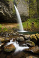
Ponytail Falls pours over a lip of the canyon, as the trail passes behind. I have some images of Ponytail Falls on some other pages... Many of the trails in the gorge intersect, which makes them hard to categorize. |
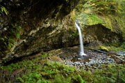
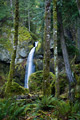
I had originally planned to visit Triple Falls, but got sidetracked on a faint footpath that headed off the main trail. I didn't know where it went, but decided to follow it. I was amazed to discover this waterfall pouring over an overhanging cliff into a cavernous bowl. The thin crevasse behind the falls stretched for a considerable depth into the rock wall. I'm sure this falls has an "official" name - I'm hardly the first to discover it. If you know what it's called, send me an e-mail. |
Hundreds of people hike to Triple Falls, but almost none of them know about this amazing waterfall just downstream. The falls is made by the main channel of Oneonta Creek - which has a pretty strong flow in the springtime. I look forward to visiting again at different times of year... |
|
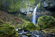
June 2005: A hike from Horsetail Falls, across Tanner Creek, and down Eagle Creek. |
This hike covered about 34 miles along both well-traveled and virtually un-traveled trails alike. It was interesting to explore some areas of the Gorge that don't see a lot of human traffic. A few miles from the trailhead, we passed by the familiar sight of Triple Falls, pictured here. |
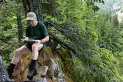
After Triple Falls, we continued up Oneonta Creek, then crossed the creek (managing to keep our feet dry) and headed up to the top of the Gorge. |
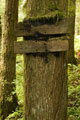
Although some of the trails had not been maintained in years, the signs were pretty good. This one pointed the way to Nesmith Point. |

After Nesmith Point, the way became quite less-traveled - the trailbed was often covered with moss. As we approached the descent to Tanner Creek, the sky broke loose with a barrage of lightning, thunder, wind, hail and rain. We descended 2000ft through the steep wet overgrowth, brushing aside Devil's Club, ducking under Vine Maple, and detouring around fallen logs. It appeared the trail hadn't been maintained in about 20 years, but it was still navigatible. The crossing of Tanner Creek was about knee-deep, but the current wasn't too swift. The ascent up the slopes east of Tanner Creek was steep, but with a steady pace, we were up in fairly good time. |
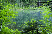
After the climb, we were ready to stop for the day. Dublin Lake is small and shallow - kind of an overgrown pond. But it was a peaceful place to set up camp and rest. |

A rough trail headed around Dublin Lake, past a number of campsites. We were the only people camping on this day however. In fact, we didn't see anybody on the trail from near the top of the Rock of Ages trail, until after the junction with the Eagle Creek - Whatum Lake trail. It was quite a bit of solitude for a lowland location so close to Portland. |
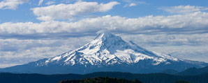
The next morning, we proceeded along Tanner Ridge, and around Tanner Butte. We considered doing a short side-hike to the top of Tanner Butte, but the hike was already long enough, and we got a decent view from the trail anyway. Mt. Hood poked just into the clouds about 20 miles to the south. |
A few miles later, we crossed Eagle Creek (another knee-deep easy ford), and headed down the Eagle Creek Trail. We passed dozens of people out for dayhikes along this popular and scenic stretch of trail, finally reaching the trailhead around 4pm. |
|
November 2003: Visits to various locations in the Columbia River Gorge |

Oneonta creek cuts a slot canyon through the walls of the Columbia river gorge. A trail crosses over the top of the falls, above the canyon. But in order to get to this spot, one has to wade through a section of ice-cold, thigh-deep water, and a good deal of calf-deep water. Unless you bring waders, your legs will become numb from the cold. |

Wahclella falls is reached by a 1 mile trail. |

Shepard's Dell is just off the old Columbia Hwy. Most people drive by without realizing there is a nice little waterfall here, along with a charming little walled-in trail. |

The old Columbia River Hwy winds between most of the waterfalls & I-84... and the railroad tracks. It was "the" highway before I-84 was built. It passes a number of waterfalls along the way. A few sections are now closed to auto traffic, but still open to bikers and hikers. |

This is a view from a bridge on the old Columbia River Hwy, just above Bridal Veil Falls. The rain paused just long enough for me to get a few nice photos. |
Where is it? The Columbia River flows from the inland northwest to the Pacific Ocean. Along the way it cuts a deep gorge through the Cascade Mountains. A number of waterfalls tumble into the river as it passes through the deepest part of the gorge. |
Before you go... Waterfall & forest photos are generally best with the indirect light of a cloudy day. You may want to avoid visiting some of the more popular areas on weekends in the middle of the summer. But, if you're willing to hike even a hundred yards on some trails, the crowds may thin-out considerably. |