![]()
|
October 2008: Visiting Crater Lake |
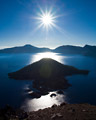
Wizard Island pokes above the still morning waters of Crater Lake. |
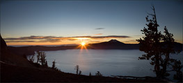
The sun pokes above a ridge just to the north of Mt. Scott - the highest point on the horizon of this image, and the highest point in Crater Lake National Park. Gnarled Whitebark Pines provide a dramatic foreground. |

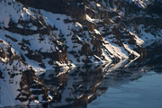
A couple Whitebark Pine skeletons part way down the rim of Crater Lake are shown in silhouette against the shimmering waters. |
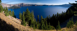
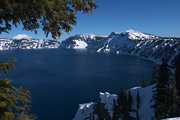
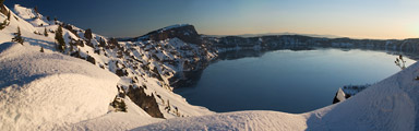
This is a view from the south rim of Crater Lake, not far from the parking area and Crater Lake Lodge. |
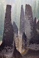
The pinnacles of Crater Lake are interesting volcanic formations. These pillars of hard rock were left standing when the surrounding softer rocks eroded. |
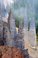
The Pinnacles are located in the far southeastern corner of Crater Lake National Park, at the end of a long dead-end road. |
|
March 2004: An overnight trip along the rim of Crater Lake |
Crater Lake is an amazing wonder of nature in the southern Oregon Cascades. The lake was formed when a volcano, called "Mt. Mazama" erupted about 7,700 years ago. The caldera collapsed and the resulting basin slowly filled with water. |
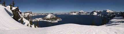
The lake level is at 6,176ft above sea level. The lake rim is generally in the range of 7,000-8,000ft elevation. Wizard island, seen here to the left of the photo, is a volcanic feature that formed after the volcano erupted. It rises 764ft above the surface of the lake. |
Crater Lake's maximum depth of 1,949ft makes it the deepest lake in the United States. There is no inlet stream to Crater Lake. The water is only replenished from snowfall or rain within the rim. The only boat traffic allowed on the lake is a summer ferry that takes tourists to Wizard Island and back. This helps keep the waters of the lake relatively pristine. |
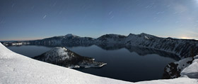
A road follows the rim around the lake. The road isn't plowed in winter. So, the only way to explore the rim in winter is to x-country ski or snowshoe. The entire route is about 30 miles. It has been skied in a day, but for most people, it's usually more like a 2-3 day excursion. This photo is a composite of two 8-minute moonlight exposures. |
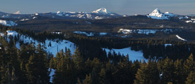
Some of the peaks along the rim of Crater Lake reach over 8,000ft in elevation. This provides a good vantage view to some other volcanic mountains in the area. Seen in this southern view (from right to left) are Union Peak, Mt. McLoughlin, and on the distant horizon, Mt. Shasta. |
The lake was known to the Klamath Indians who once lived in the area, but was not "discovered" by western eyes until 1853. Crater Lake National Park was established in 1902. |
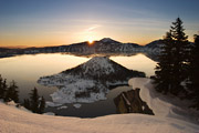
Here the sun rises over the rim. Its the start of another fantastic day in this magical place. |
Where is it? Crater Lake is in the Southern Oregon cascade mountains. |
Before you go... Crater Lake is in a National Park, so the regular national park administration guidelines apply. In the winter, the road to the "rim village" area (on the south rim) is plowed & open (weather permitting). The road around the rim isn't plowed, and may remain snowbound well into June. |